
TOPOGRAPHIC
Surveys
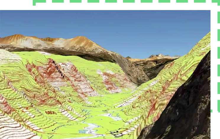
WHAT IS IT ?
If you are looking for top-notch and tailored topographical survey services for your next construction project, land development or architectural design, S2P has you covered! We combine traditional techniques with innovative and specialist equipment to highlight features such as buildings, trees, streets, maintenance holes, retaining walls, and utility poles. Our services are aimed at helping you build a complete picture of your site.
Topographical Surveys –
Why Work with S2P?

Architectural Technician-Crafted Models and Drawings

S2P stemmed from frustration emanating from poorly modelled surveys. Therefore, we gathered the best of BIM experts, architectural technicians, surveyors, and engineers on a single platform with the sole objective of delivering accurate and detailed models and drawings.
When you handover your project to us, you gain access to top-notch surveying expertise. S2P is the only surveying company across the UK that hands over your data to qualified architectural technicians who prepare detailed architectural models that are not only accurate but meticulously detailed and thoroughly validated.
The same underscores S2P’s commitment to deliver unrivalled quality to you as we believe in fostering lifelong relationships rather than focusing on securing a single project.
Unlike some practices that rely on CAD technicians or surveyors, our emphasis on the expertise of Architectural Technicians underscores our commitment to delivering unparalleled quality. These professionals bring a unique skill set, blending architectural knowledge with technical proficiency, resulting in designs that seamlessly integrate creativity with functionality.
Software Flexibility

We know every project is unique and comes with its diverse needs. Therefore, we take pride in offering flexibility by accommodating plans in a wide array of software tools such as Revit, Vector works, or any other 2D AutoCAD software that you will prefer. This adaptability has enabled us to seamlessly meet individual project requirements and integrate our models and drawings into existing workflows.
Validation Before Issuing Models or Drawings

Before issuing models or drawings to you, we validate them by passing the same through rigorous QA process. Our architectural technicians perform a stern scrutiny to ensure that models or drawings you get are not merely a representation but a true reflection of your architectural vision.
Likewise, you can receive designs in your preferred format as we offer the options of PDF and paper files. Our approach to topographic survey is an all-encompassing technique that ensures exceptional results for your topographical surveying needs.
Cutting-Edge Technology

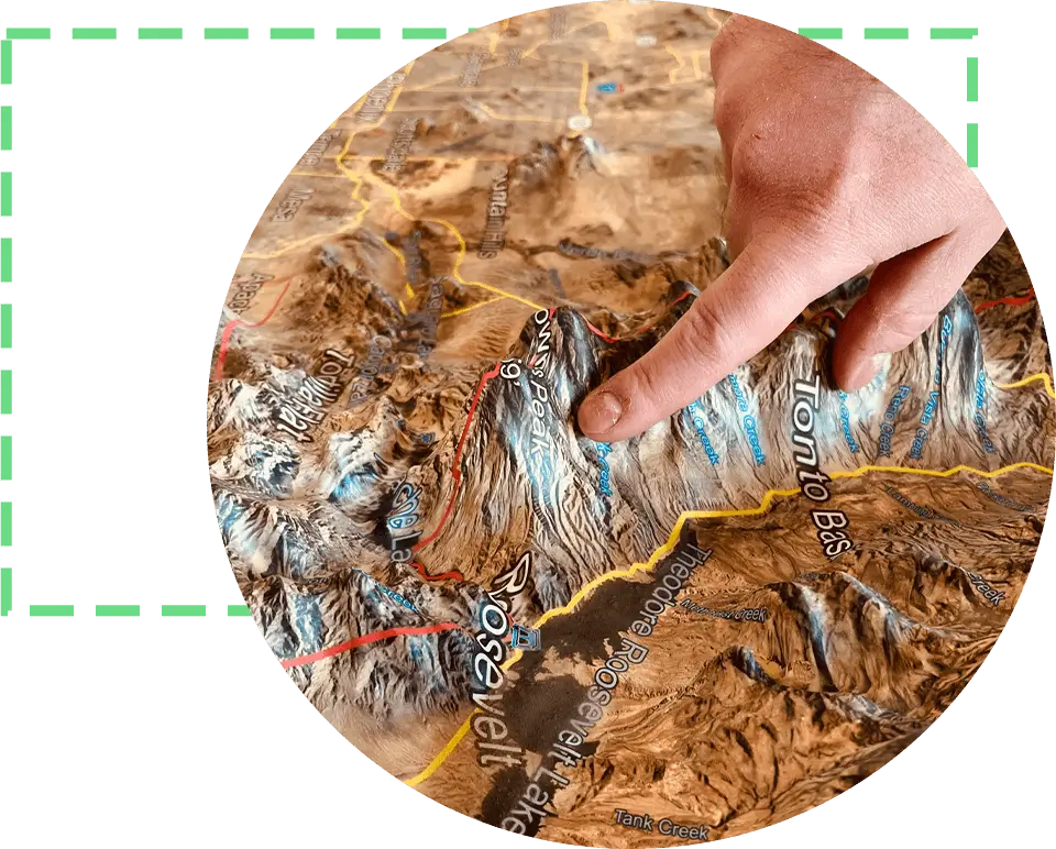
We use cutting-edge technology along with traditional techniques to deliver exceptional survey results. Using specialist equipment such as Total Stations enables us to deliver accurate and detailed models.
Total Stations are cutting-edge surveying equipment that combines excellence of electronic theodolite, electronic distance meter, and microprocessor techniques. This combination helps Total Stations to combine multiple functions into a single device, significantly enhancing overall accuracy and efficiency.
Dedicated Account Manager

One of the core values of our topographical survey service is to provide personalized and seamless experience to our clients. From initial consultation to project completion in the form of issuance of drawings or models, we assign you a dedicated account manager. This manager becomes the single point of contact who thoroughly grasps the intricacies of your project and translates the same to our technical team.
The motif behind assigning a dedicated account manager to each new client is not merely delivering exceptional service but also cultivating lasting relationships.
Up to 10 Revisions

Being a highly experienced and diverse team, we understand that the journey from concept to completion is dynamic. This journey often requires adjustments and fine-tuning and to cater to the same, we offer up to 10 free revisions. This means that even months after the model has been delivered, we remain steadfast by your side, ready to assist and refine as your vision evolves.
Honesty & Transparency

We uphold a steadfast commitment to honesty and transparency and the same is reflected in our pricing philosophy. The price quote that you will receive after the initial consultation is the price you will pay. We do not charge any hidden fees. This transparency in the pricing allows you to optimize your costs throughout the project lifecycle.
Likewise, we believe open communication is key to successfully navigate the complex world of construction and design. When all aspects of the projects are well-defined such as project timelines and potential challenges, our dedicated manager will communicate openly and with utmost honesty.
Benefits of Topographical Survey
Following are the benefits of topographical survey:
1. Get Full Picture of Land
When it comes to the complex world of design and land development, it becomes paramount that you gain an in-depth and detailed understanding of the land. This is where our topographical surveys step in. By going beyond surface-level assessments through machines such as Total Stations and 3D Laser Scanning, we provide you with a holistic view of the site, covering both on-site and off-site features.
This detailed analysis enables you to gain invaluable insights into potential constraints and engineering challenges throughout the project lifecycle. By gaining this understanding beforehand, you can craft a robust design process. Thus, topographical surveys – when done accurately – become lens through which you can capture nuances of the land such as on-site, off-site, and near-site elements.
2. Eliminates Risk of Costly Mistakes
When it comes to design and construction, you know it better than us that even the tiniest of mistakes can result in costly reworks, fines, and legal repercussions. Topographical surveying becomes a shield against such costly mistakes as they help you identify and mitigate issues that might otherwise remain hidden.
As this type of surveys entail detailed and meticulous examination of the land that encompasses on-site, near-site, and off-site elements, they empower you and other stakeholders to identify potential and hidden challenges that can disrupt the seamless flow. The nature of these challenges can vary such as hidden subsurface utilities, unstable soil conditions, and impact of neighboring structure. These surveys highlight these challenges in the exceedingly early stage of development thus enabling architects, engineers, and developers to fix them head-on.
All of this translates into significantly minimizing the likelihood of expensive mistakes throughout the project lifecycle.
3. Strategic Decision-Making
The ability of these surveys to identify potential challenges in initial stages facilitate strategic decision making. When engineers, architects, and all other stakeholders are armed with a thorough understanding of the terrain, they can design strategies that cater to identified challenges.
4. Provide Additional Information to
Design Team & Consultants
Topographical surveys provide critical information to both the design team and consultants at the preliminary stages of the project, thus helping you save time and money. This information includes site levels, spot levels, defined boundaries, and tree data.
For the design team, site levels and spot levels are not less than breadcrumbs as they guide them through the complexities of the terrain. Using this information, your team can tailor their designs to align with natural contours of the land.
Similarly, as these surveys entail the three data, they enrich the early-stage information available to your design team. Early knowledge of the tree canopy helps designers plan layouts, envision spaces, and implement strategies. This wealth of information is available to all stakeholders including designers and consultants, allowing your team to work in tandem.
DO YOU HAVE ANY QUESTIONS?
FAQs
How Do Topographical Surveys Benefit Your Project?
These surveys bring a wealth of data in the form of 3D models, drawings, and charts. You can use this valuable information to
- Pick the right location for new projects such as construction of new building
- Avoid encroaching over boundary lines or on buildings
- Contemplate possibility of re-positioning current boundaries
- Locate natural topographic features to identify need for additional surveys to get through planning
- Discover prospects to increase value of your development
- Navigate through and slash risks emanating from natural features such as streams, soil, and slopes.
- Mitigate the risk posed by natural features like streams, slopes, and soil.
- Choose the best location for your proposed structure
- And consider on-site, off-site, or near-site risks that could cause engineering challenges throughout project life.
Does Your Project Need a Topographical Survey?
In a country like United Kingdom that consist of vastly different and diverse terrain, there is no one-size-fits all answer. It means every project comes with its unique sets of opportunities and challenges. And if your project is more complex or large, the intricacies associated with it will be huge. To navigate through these complex challenges seamlessly, you will need topographical surveying services.
Thus, if your project requires this survey but you don’t opt for it, the repercussions could be huge, ranging from costly reworks to minor boundary issues, and from project delays to potential structure collapse if something is built too close to the retaining wall.
How Long Does a Topographical Survey Take?
It depends on the unique requirements of your project. However, when you book a free consultation with our experts, we will try to send over a quote within 24 hours. Once you accept our quotation, we will dispatch the team to your site. In the last phase, our architectural technicians will provide you with data after thorough validation in your desired format. Usually, this complete process is completed within 7 working days. The topographic survey cost varies from project to project.