Utilities and Drainage
Surveys
WHAT IS IT ?
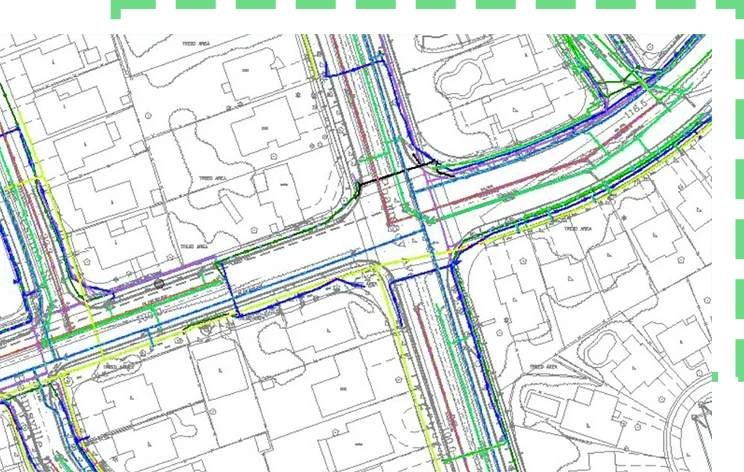
Utilities and Drainage service is S2P’s powerful utility mapping service that helps you identify critical underground features thus helping you to proactively plan operations before ground excavation commencement of your project. To help you safeguard the safety of your workers and the public, we’ll provide you with detailed 2D plans or 3D models about the whereabouts of the subsurface utilities’ infrastructure.
Being completely UK-based, we understand compliance inside out. Therefore, our work is BSI standards “PAS 128” and ISO 19650 compliant. Likewise, our utility mapping service seamlessly integrates with topographical and measured building surveys to give you a comprehensive and accurate site analysis, mitigating cable strikes during ground works or submitting planning applications.
Utilities and Drainage Survey – What Sets S2P Apart?
We are not just another utilities and drainage service providers. We were born out of frustration with poorly modelled surveys from traditional surveyors. As a team of BIM (Building Information Modeling) experts, modelers, engineers, and architectural technicians, we take pride in delivering exceptional models that are accurate, geo-coordinated, and tailored towards your project delivery.
Therefore, partnering with S2P will unlock a wealth of benefits and expertise. Let’s delve deep into details to find out more

Dedicated Account Manager Your Point of Contact

At S2P, we strongly believe that every project has unique requirements. Therefore, when you hire us for utility mapping service, you get a dedicated account manager. The manager acts as a single point of contact, providing you with in-depth guidance throughout the project. Likewise, your dedicated account manager will thoroughly understand your needs and communicate the same to us, ensuring every aspect of your project is catered for with precision.
Up to 10 Free Revisions

We believe in fostering lifelong relationships and therefore, our commitment to your project doesn’t end with delivery of a 2D plan or 3D model. We offer 10 free revisions. This isn’t just peace of mind; it’s a testament to our dedication to your project’s success.
Honesty & Transparency No Hidden Fees, No Surprises

Transparency and honesty are at the core of our ethos. When you receive a price quote from S2P, it will be the final amount that you’ll pay. We do not charge any hidden fee or unexpected costs. We strongly believe that trust is earned through transparency and exceptional services.
Our People A Team Aligned with Your Vision

When you hire S2P for your project, you get access to a diverse set of expertise. Our team comprises BIM experts, engineers, architectural technicians, and modelers. Therefore, you’ll get results that will meet and exceed industry standards. Our experts will hold a thorough project kick off meeting with you to thoroughly understand the intricacies of your project. So, when you work with S2P, you get a team who is seriously invested in the success of your project.
Cutting-Edge Equipment

Fully Compliant

When it comes to the construction industry, precision and adherence to industry standards is non-negotiable. Non-compliance can result in fines, costly reworks, and legal repercussions. That’s why our utility survey service fully aligns with strict BSI standards PAS 128 and ISO 19650 standards. Adherence to these strict standards underscores our commitment to project excellence. Furthermore, it also highlights the fact that your utility and drainage survey requirements are met with the highest level of precision and professionalism.
It is pertinent here to mention that PAS 128 standard stands as a benchmark for precision and accuracy vis-à-vis utility mapping service. When we say we adhere to PAS 128 standard, it means you get 2D plans or 3D models that are reliable and exceed industry standards.
Likewise, ISO 19650 focuses on information management in the built environment. Adherence to this standard translates into efficient collaboration and streamlined information management in utility mapping service.
Adherence to the aforesaid two standards ensures accuracy, interoperability, risk mitigation, and future proofing.
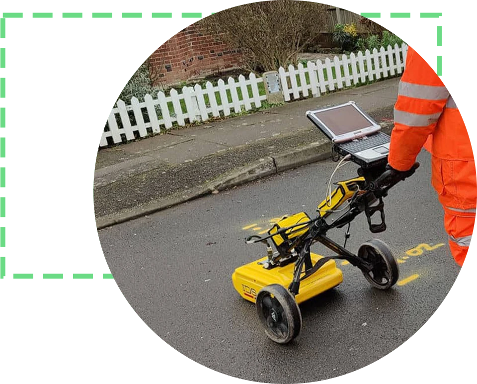
Utilities and Drainage Service – Ground Penetration Radar
It is impossible to ensure precision in utility detection and mapping without innovative technology. Therefore, we use state-of-the-art ground penetration radars (GPR). This revolutionary technology helps our experts to gather all sorts of information pertaining to subsurface services including the utility’s location, depth, size, and type.
Utility Location
The world of construction and infrastructure development is complex and so is the planning associated with it. And for any planning to deliver desired results, accurate data and information is required. We leverage the latest tools and technology to provide you with the exact location of subsurface utilities, ensuring that the data you get becomes foundation pillars of effective planning. Likewise, the data you get increases efficiency to the maximum levels while slashing risks.
Utility Depth
To ensure safe excavation and construction activities, it is possible for you to understand the exact depth of subsurface utilities. And this is what you get from the Survey2Plan. By delivering precise insights into the depth of underground utility survey services, we empower your team to make informed decisions and reduce the risk of accidents and disruptions during construction.
Size of Subsurface Underground Services
Just like depth and location, the access to accurate data about the dimensions of subservice is also paramount for successful project planning. Our 2D and 3D modeling services extend the precision of our utility mapping into actionable visual insights. This information helps you gain a thorough understanding of what you need to design and execute your projects with precision.
Type of Utility
Leveraging the latest tools, we discern the type of subsurface utility present beneath the surface. Be it electrical lines, water pipes, plastic pipes, telecommunication, or any other type of infrastructure, we use the latest technology to provide you with the exact details and nuanced understanding of the complex subsurface environment. All this information translates into successful project completion.
FAQs
What is a utility mapping survey?
Underground utility surveys are designed to discover, locate, and verify all statutory services and any subsurface structures and features. As no digging is required with Ground Penetration Surveys, they are safer and non-intrusive. We can record the different features and their location directly on the ground and of course in CAD either in 2D or 3D.
What is PAS128 & why is it important?
The PAS128 was issued British Standards Institution (BSI) as it’s industry standard guidelines
This was created to give confidence and guarantee to the construction by ensuring that utility survey information is captured with specified level of accuracy and delivered in standardized format. This was achieved by providing guidance on both the methods used for detection, as well as how the information is categorized and delivered to clients.
The hierarchy of PAS 128 standards surveys is as follow
- PAS 128 Level A It concerns observing, excavating, and exposing underground utilities.
- PAS 128 Level B It concerns detecting subsurface utilities through geophysical techniques.
- PAS 128 Level C It concerns validating utility records through visual inspection
- PAS 128 Level D It concerns desktop utility record search.
How much does a utility mapping survey cost?
The cost of an Underground survey can vary depending on the size of the property or land and the project’s complexity. The cost of an Underground survey is made of two part field work (which includes travelling cost) and office based data processing (for Example Revit modelling). We charge a daily rate of £650 per day multiplied by the number of days required on site. How many days we will be on site vary based on factors such as PAS128 requirements. Work regards to the modelling work we charge a flat rate of £275 per day.
Our prices are usually lower as our experienced team can get the work done more efficiently so get in touch for a free no-obligation quote
What deliverable will I receive?
We can produce detailed 2D plans or complex ISO19650 compliant 3D model. We spend time to understand your requirement and one of our architectural technicians will produce a output based on your project delivery needs. As always, we offer up to 10 free revision to give you peace of mind.
How quickly will you complete the drawings?
Our current lead time to get to your site is two weeks. The time spend on drawing is based on the size and complexity of the project, and drawings. Your quote will contain a delivery date and we will remain communication with you throughout the survey and drawing processes.
I am not sure what I need for my project, can you help?
Our Team is made up of architectural, engineers and BIM consultants so we are happy to take the lead and speak to your design team directly. With a combined experience of 30+ years, we take pride in delivering results that meet and exceed all expectations.