

While working on a construction project, have you ever wondered about the intricate details of a landscape? Or the secrets it might hold that are present beneath its surface? For an untrained eye, the landscapes might not be anything more than just the landscapes. But it’s the science of topography that reveals insightful information for making wise decisions – especially in the context of urban development, environmental conservation and infrastructure designs. In this blog, we will focus on the art & science of topography and also share what a topographic survey is.
We have divided our blog into multiple sections for a better understanding of the information that we are about to share. Make sure that read the blog till the end to know more and decide better!
Importance of Land Surveys in Various Fields
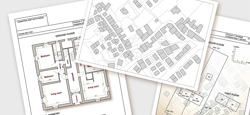
Land surveying also includes Topographical Surveys. What these surveys do is that they offer accurate measurements and vitally important insights. The valuable insights, then ease the process of data collection and serve as the linchpin for getting to know the landscapes better. Know that the fundamental information gathered after conducting land surveys is crucial for multiple types of decision-making.
Let’s explore what Topographical Surveys are in detail!
What is a Topographic Survey?
A Topographical Survey has many different names which are all valid and can be used on multiple occasions. For example; Topographic Surveys, Topo Surveys, Topological Surveys, Topology Surveys, etc.
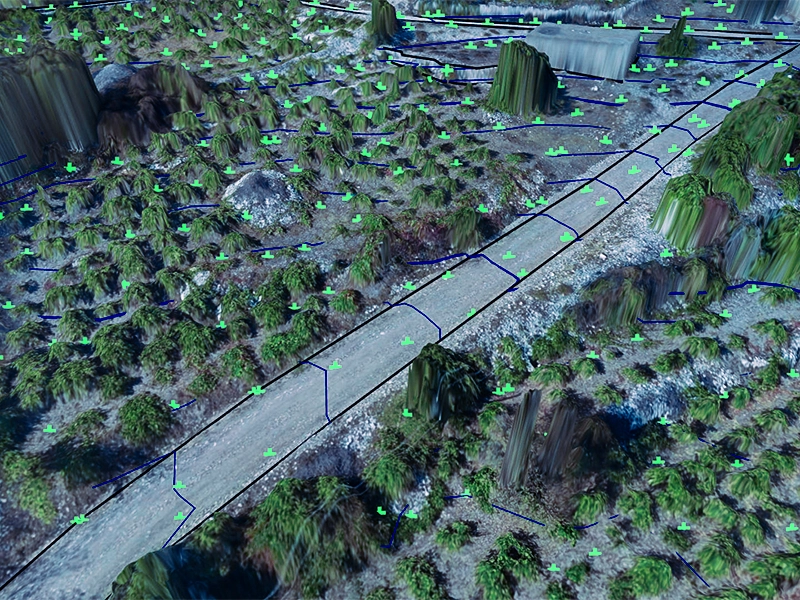
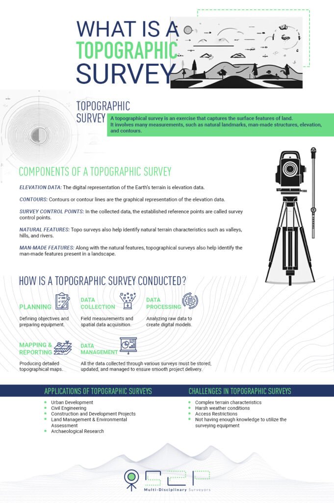
As we have briefly mentioned above, a topographical survey is an exercise that captures the surface features of land. It involves many different types of measurements such as natural landmarks, man-made structures, elevation and contours. This crucial information serves as a comprehensive account of what a piece of land really is.
Allow us to take you guys back in time to learn a little bit about the Topographical Surveys!
Brief History of Topographical Surveys
The individuals associated with development, civil engineering, etc. can get their hands on precise data. The data proves to be instrumental in efficiently shaping the infrastructures and then some more. It’s important to mention that the modern society we happen to see today is a result of detailed topographical surveys. In this part of the blog, we would like to highlight some applications of the Topographical Surveys:
Applications of Topographical Surveys

Topography continues to help individuals across multiple fields and sectors. Continue reading the blog to know more about its applications.
1. Urban Development
Topo surveys are extremely helpful when it comes to urban planning and development. These surveys benefit the development of infrastructures and also in city expansion.
2. Civil Engineering
Topology surveys provide crucial data that benefit civil engineers in different ways. This data is helpful when it comes to designing roads, railways, bridges etc.
3. Construction and Development Projects
Site evaluation can be a tiring process, we all know that, right!? However, with topographical surveys, the process of site evaluation becomes easy and efficient. In addition to that, topo surveys are also beneficial for earthwork planning and foundation design.
4. Land Management & Environmental Assessment
Topological surveys are extremely helpful in land management as well as environmental assessment. Furthermore, these surveys also support sustainable practices as well including conservation and land-use planning.
5. Archaeological Research
If you didn’t know about this before then you will be delighted to know that a topographic land survey can also facilitate in archaeological research. With topo surveys, archaeologists can easily identify sites that have significant history attached to them. After getting hands on useful insights, the individuals can also plan excavation activities accordingly.
There are multiple components of a typographical survey. And in this part of the blog, we aim to focus on those components. Make sure that you guys read the blog till the very end!
Different Components of a Topographic Survey
-> Elevation Data
The digital representation of the Earth’s terrain is elevation data. This data can be represented using points such as x, y, and z. Or in the form of gridded formats also known as raster. This data is collected by utilizing topographic survey equipment. The equipment includes GPS receivers, laser scanners as well as total stations.
-> Contours
Contours or contour lines are the graphical representation of the elevation data. This data also includes the connecting points of equal elevation across a certain landscape. Contours are utilized to get hands on visual representations of landform characteristics. These characteristics can include valleys, hills, ridges, etc. These features can help understand the terrain better for analysis and visualization.
-> Survey Control Points
In the collected data, the established reference points are called survey control points. These control points have known coordinates attached to them to ensure accuracy and consistency in the data. Topographical surveyors utilize these control points for survey networking as this data enables precise spatial referencing and integration of data.
-> Natural Features
Topo surveys also help in identifying the terrain’s characteristics that are natural such as valleys, hills, rivers, etc. In addition to that, areas with vegetation can also be determined by conducting topo surveys. When a topographical surveyor has access to such detailed information, they can also determine the land’s ecological diversity.
-> Man-made Features
Having said that, we would now like to talk about the process of conducting a topographical survey. We are sure that you were able to learn many things today so let’s dive into the complexities of a topographical survey now!
How a Topographical Survey is Conducted?
The process of conducting a topographical survey is a detailed one – covering a number of steps:
1. Planning & Preparation
This step of conducting the topo survey covers defining the survey objectives. The Topo surveyors identify the appropriate methods to conduct the survey. And then also prepare the suitable surveying equipment to get started.
2. Data Collection
This step takes the surveyors to the field where they are assigned to collect the required data. The process of data collection includes conducting on-site measurements and determining elevation data. Data collection also enables getting spatial information by making the most of the surveying instruments.
3. Data Analysis and Processing
The step of analysing the data and processing it allows going through raw data and then generating digital elevation methods (DEMs). The surveyors and other concerned individuals can then evaluate terrain characteristics by utilizing modern techniques and software.
4. Mapping & Reporting Processes
5. Data Management
Conducting topo surveys facilitates multiple operations and individuals during the lifecycle of a project. However, the process has some challenges and limitations attached to it. Let’s have a look at them to better understand the overall process.
Challenges and Limitations attached to Topographical Surveys
- Complex terrain characteristics
- Harsh weather conditions
- Access restrictions
- Not having enough knowledge to utilize the surveying equipment
Previous Post
Next Post
What is a Building Survey? →