The uses of topographic maps are vast and far reaching. Topographic maps are used for a wide array of purposes including but not limited to engineering, environmental management, resource conservation, commercial use, residential planning, and outdoor activities like hiking, camping and fishing. Likewise, topographic maps are also used for public work designs.
Before exploring these uses in detail, let’s first explore what topographic maps are.
What is a Topographic Map?
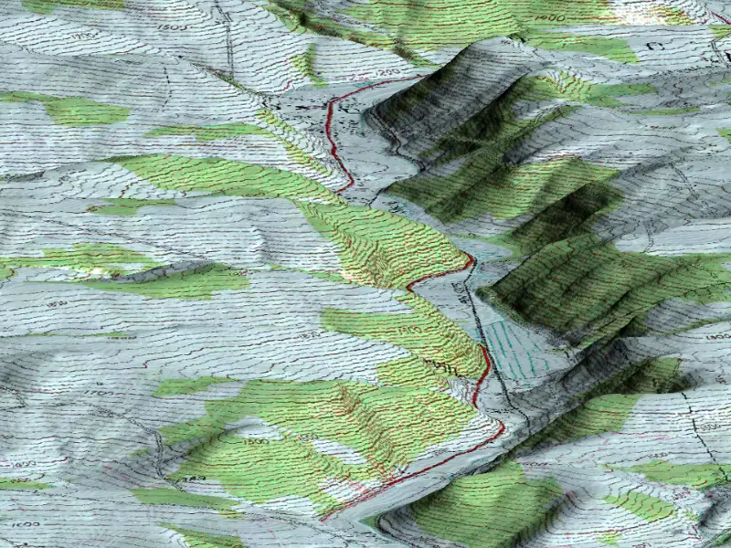
As per USGS, topographic maps are the kind of maps which use contour lines to portray the shape and elevation of the land. Topographic maps render the three-dimensional ups and downs of the terrain on a two-dimensional surface.
To accurately read topographic maps, one must understand how these maps usually portray both natural and manmade features. They show and name works of nature including mountains, valleys, plains, lakes, rivers, and vegetation. They also identify the principal works of man, such as roads, boundaries, transmission lines, and major buildings.
Learn more about choosing a right topographic surveyor for your land development project.
Uses of Topographic Maps
1. Engineering Applications
Topographic maps are an extremely valuable tool for engineering endeavours. They come extremely handy in different phases of project lifecycle such as planning and design of the infrastructure projects. Topographic maps help engineers understand the physical characteristics of the landscape. This understanding is crucial for designing roads, bridges, and dams.
With access to detailed elevation data, engineers assess the feasibility of construction projects and make informed decisions about the placement of the structures.
For instance, when engineers have access to detailed maps, they can know the slope of the land better and thus, determine the best location for roads to minimize costs and environmental impacts.
The relationship between topographic maps and engineering does not end here. Engineers use these maps to pick the best location for site. How? Well, engineers use these maps to identify potential sites for construction, considering factors such as slope stability, drainage patterns, and the risk of landslides.
2. Energy Exploration
Another area where topographic maps play a crucial role is the energy sector. Using detailed topographical maps, stakeholders locate potential sites for drilling, mining, and other resource extraction activities. Furthermore, geological companies use these maps to identify geological formations and structures that might contain oil, gas, or other minerals.
Experts analyse contours and elevations of the topographic maps to pinpoint areas where resources are likely to be found; the same are used to assess accessibility of these sites.
It’s not the conventional energy sectors that benefit from topographic maps, renewable energy sector also harnesses the data extracted from topographic maps to plan new projects. For instance, stakeholders need to know the exact location and knowledge of terrain elevations to pick the best locations for installing wind turbines.
It is because wind speeds get influenced by topography off the given land. In the very same manner, solar farms harness the power of topographic maps to pick up the sites that offer maximum sun exposure and slashes the shading from nearby hills, mountains, or buildings.
3. Natural Resource Conservation & Environmental Management

Topographic maps are widely used by conservationists and environmental managers to both monitor and manage natural resources. These maps help stakeholders track changes in landscape over a period. These changes include deforestation, erosion, habitat destruction, among many others. As these maps help the aforesaid managers to develop better understanding of any given area, the latter uses it to devise strategies to protect endangered species.
And you may have stumbled upon the famous saying that the next world war will be fought on water. Well, topographic maps can help us prevent it! These maps provide crucial information about watershed boundaries, river networks, and floodplains, enabling effective planning for water conservation and flood prevention. For example, topographic maps identify areas at risk of flooding and guide the construction of levees and other flood control structures.
When it comes to environmental management, topographic maps help stakeholders to understand the impact of human activities on natural environments (poignantly, it’s not laudable). Using these maps, environmental managers evaluate how construction projects, industrial activities, and land use changes affect the terrain and ecosystems. Topographic data is crucial for conducting environmental impact assessments (EIAs) and developing mitigation strategies to minimize negative effects.
4. Public Works Design
5. Commercial and Residential Planning
Topographic maps play a crucial role in commercial and residential planning. These maps are used by architects and developers to determine the best locations for buildings by taking into account various factors such as elevation, slope and drainage. Topographic maps ensure that developments are safe from natural hazards, such as flooding and landslides, and that they harmonize with the surrounding environment.
📍 Transform Your Plans with Reliable Topographic Mapping!
Survey2Plan ensures precision and detail in every survey. Get in touch for expert mapping services tailored to your needs.
📞 0161 531 6641 📩 info@survey2plan.com 💬 Get a Quotation
Fast & Accurate Surveys | Trusted by Architects, Developers & Contractors
Topographic Maps – The S2P Advantage
With S2P (Survey2Plan), you get
- Architectural technicians crafted model and designs
- Dedicated account manager
- Software flexibility
- Validity before issuing models or designs
- Up to 10 revisions
We combine traditional techniques with innovative and specialist equipment to highlight features such as buildings, trees, streets, maintenance holes, retaining walls, and utility poles.
Our topographic survey services are aimed at helping you build a complete picture of your site. So, book your consultation today to eliminate the risks of costly mistakes and get precise topographic maps!


