


Do you know about the various types of drone surveys? Or that those surveys are literally reshaping a couple of industries across the globe? Well, today’s blog focuses on the diverse types of drone surveys and how they improve efficiency and accuracy. Make sure to read the blog till the end to equip yourselves with insightful information.
What is a Drone Survey?
- Red, Green, Blue colours of light
- Light Detection and Ranging
Types of Drone Surveys

1. Orthomosaic Surveys
An Orthomosaic survey is conducted by using a drone-mounted camera. This survey involves capturing multiple overlapping images of the area that is being surveyed. Once the survey has been conducted, the images are stitched together. This process is completed by utilizing specialized software that creates a high-res, georeferenced Orthomosaic map. An Orthomosaic survey offers a highly detailed representation of the landscapes. The collected data offers invaluable insights for urban planning, infrastructure development and more.
Allow us to also mention that you can get two types of maps by conducting Orthomosaic surveys:
- 2D Orthomosaic Maps
- 3D Orthomosaic Maps
2. Topographic Surveys
Also check: What is a Topographic Survey?
3. Thermal Surveys
Thermal surveys are instrumental in the identification of energy leaks and crop stress. Once the surveyors find thermal abnormalities in a surveyed area, they can take proactive measures for risk mitigation.
4. Cadastral Surveys
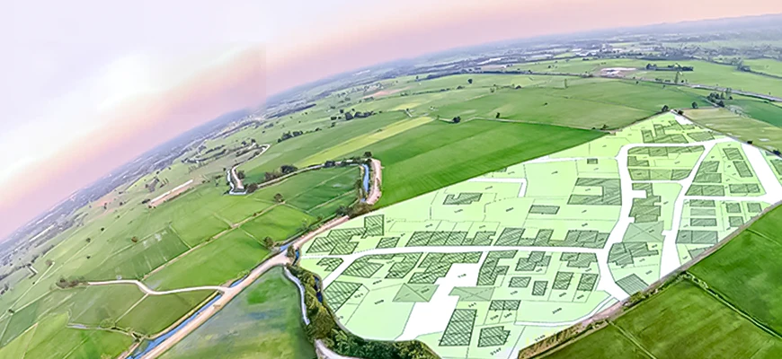
This survey is performed to map and delineate land boundaries and property parcels. The drones that are used to conduct this type of survey are equipped with GPS receivers and high res. cameras. By making the most of modern equipment, the surveyors can get their hands on accurate and detailed cadastral data. Cadastral surveys are usually performed to determine real property’s metes-and-bounds of a country. If the goal is to achieve transparency in land administration, then Cadastral surveys are the solution.
Among the various benefits of Cadastral surveys, we must also mention that the collected data facilitates dispute resolution among authorities.
5. Hydrographic Surveys
6. Vegetation Monitoring
Drone surveys are quite helpful when it comes to vegetation monitoring – facilitating the agriculture sector. The drones that are used to perform vegetation monitoring are armed with multispectral or hyperspectral cameras. The purpose of those cameras is to collect data in areas that are not accessible to the human eye.
Now, what happens after vegetation monitoring is that farmers and other stakeholders can analyze plant / crop health. In addition, they can also manage species distribution by considering environmental challenges and related hazards. We must mention that various sectors benefit from vegetation monitoring such as:
- Agribusinesses
- Forest management authorities
- Environmental scientists and ecological researchers
7. Environmental Monitoring
Speaking of vegetation monitoring, we would also like to share that drone surveys are also helpful in environmental monitoring. What happens in this type of survey is that the natural ecosystems are monitored. And in addition to that, environmental scientists can also monitor air quality and pollution levels. In addition, wildlife habitats can also be inspected to protect the endangered species.
By utilizing the data collected through environmental monitoring, the concerned authorities can help in issuing early warnings regarding potential ecological disruptions.
8. Volume Calculations
It’s a fact that drone surveys serve many different types of industries and businesses. Allow us to share that drone surveys are also beneficial for extensive volume calculations. Volumes of materials are usually calculated in areas such as construction sites and factories. In addition, stockpiles and quarries are also to be monitored where necessary.
Volume calculations are conducted by using LiDAR data from different angles. The collected accurate data can be in the form of calculating the volume of sand, gravel, etc. Facility managers can then utilize the information to streamline inventory while the rest of the stakeholders can improve project monitoring.
Having shared the multiple drone survey types, we would now like to share a couple of advantages of performing them.
Key Advantages of Conducting a Drone Survey
Drone Surveys Are Cost-Effective
Drone Surveys Are Time Efficient
Drone Surveys Ensure Safety

Ensuring the safety of the team members is crucial for any project. Drone surveys majorly contribute towards safety concerns as compared to conventional surveying methods. When drones are utilized to conduct surveys, the surveyors can capture data from a safe distance. So, it is safe to say that drone surveys ensure project success by enhancing safety for surveyors.
Previous Post
← Equipment Used in Measured Building SurveyNext Post
Aerial Surveying Vs. Drone Surveying →